
Birsav CBS — Kentin Dijital İkizi
Combining all the geographical data of the municipality in a single 2D/3D map; CBS platform, which automatically produces the e-zoning diameter and captures the illegal structure from the satellite.
7+
6
4
Website
CBS Platform Bringing City Data to the Map, Analysis and Operation Layer
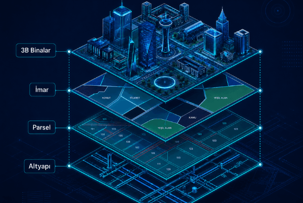
Geographic Information System, which combines the municipality's geographic data — 3D buildings, zoning plans, parcels and infrastructure layers — in a single map. Automatically produces e-zoning diameter from digitized 1/1000 plans; With Parcel 360, it compares historical parcel data with the current situation and captures unlicensed growth on the map. AI supported field radar matches the satellite image with license records. IP marks suspicious structures without waiting for notice. It works with the PostGIS + GeoServer infrastructure and the fluent vector tile engine in the browser. Biryerden is the spatial layer of the Kamu Karar Destek Platformu family.
Operational scope
Problems Solved & Value Delivered
Geographic data were scattered across units; Information was available via correspondence.
Unlicensed/expanded buildings are not declared and revenue leakage occurs
Building stock and risks could not be monitored on a single screen
Coordinate-based data in seconds instead of correspondence
Not illegal reporting, but evidence-based proactive inspection
Income without loss with zoning-declaration matching
Technical Features & Modules
Single map, layered architecture — 3D buildings, zoning, plots, infrastructure
Automatic e-zoning diameter production (numerical 1/1000 plans)
Rising 3D city skyline with license data
Parcel 360 — historical/current comparison, owner-property-declaration cards
AI field radar — satellite scanning → license matching → suspect detection → field verification
Disaster crisis map — risky building stock and instant field notifications
Vector tile map engine — smooth in-browser rendering on large layers
Directing field additionalIPs to pinpoint coordinates
Explore the project through its presentation
Use arrow keys or scrolling to move between slides.

See this project in your organization
Fill out the form and we will plan a tailored demo or return with a similar project proposal.
Explore our other field-tested projects
Let's Discuss Your Project
We'll listen to your requirements, schedule a custom demo, or provide a quote within 24 hours.